Soggyblog Leave a reply
To simply state that there is water everywhere just doesn't do justice to our current state of affairs.
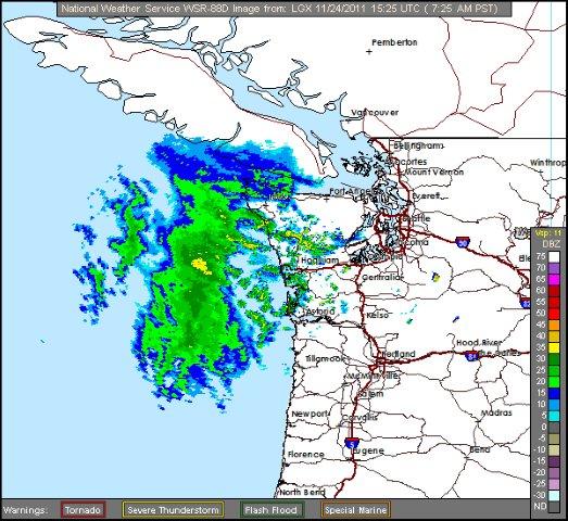
At least we are armed with more information for this season's series of November drenchers. Thanks to the new Langley Hill radar we have a better view of incoming fronts.
This new view is particularly helpful to coastal residents but also invaluable to Olympic Peninsula bound anglers. This morning's view shows another front heading our way.
My primary concern with November gully washers is the fate of our wild salmon populations that have spawned and placed their fragile eggs in the gravel. This fall in particular we have a good run of pink or "humpies", coho and chinook eggs already incubating in our area streams.
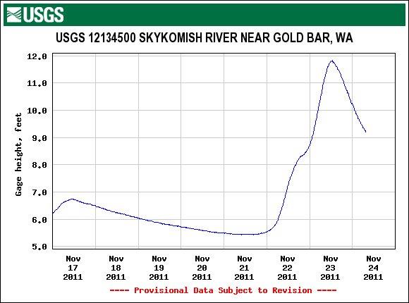
Generally when we experience an early November cold snap that dumps the first real mountain snows, the table is set for a tropical moisture tap or "Pineapple Express" (warm rain) to quickly melt the early snow and provoke a serious November flood. Thanks to our current, colder "La Nina" pattern, the low pressure systems hitting us are originating from farther north. UW Meterologist Cliff Mass calls these the "Sushi Express".
Although these cooler systems are not as severe, they still have a tremendous effect on our rivers. Here is this morning's Skykomish River USGS graph showing the "rain on snow" effect! You can see that there is a little window of opportunity to hit the rivers as they should remain on the drop throughout Turkey Day!
While our rivers get a breather, Puget Sound will remain a little "sporty" given the Gale forecast for the Holiday weekend!
PZZ135-241715-
PUGET SOUND AND HOOD CANAL-
300 AM PST THU NOV 24 2011
…GALE WARNING IN EFFECT…
TODAY…S WIND 10 TO 20 KT RISING TO 25 TO 35 KT IN THE AFTERNOON. WIND WAVES 1 TO 3 FT BUILDING TO 4 TO 6 FT THIS AFTERNOON. RAIN BY AFTERNOON.
TONIGHT…SW WIND 25 TO 35 KT EASING TO 10 TO 20 KT AFTER MIDNIGHT. WIND WAVES 4 TO 6 FT SUBSIDING TO 1 TO 3 FT. RAIN TURNING TO SHOWERS.
FRI…S WIND 10 TO 15 KT. WIND WAVES 1 OR 2 FT. CHANCE OF SHOWERS IN THE MORNING.
FRI NIGHT…S WIND 10 TO 20 KT. WIND WAVES 1 TO 3 FT.
SAT AND SUN…S WIND 15 TO 25 KT. WIND WAVES 2 TO 4 FT.
So, what's an outdoor's minded fella to do this weekend?
If you're an upland hunter, the last pheasant releases of the season take place on Thanksgiving weekend and since many Western Washington release sites feature a bit of waterfowl habitat…well, you get the picture.
Several area lakes have been planted with jumbo rainbow trout and they will be biting right up to the next real frost and beyond. Check WDFW's website for a listing of recently stocked lakes.
If you're just hung up on steelhead and salmon, my advice for you is to take advantage of the dropping streams and temporarily calm waters and make a break for it!
If you can't bargain an out pass or sneak out the back door, you're resigned to eat turkey, watch football and tie some leaders….Get ready for December! It's gonna be a good one!!!
Tom Nelson
The Outdoor Line
710 ESPN Seattle
www.theoutdoorline.com