Time To Go Tuna Fishing!! 1
We talk on the show all the time about the tuna highway, targeting the warm water, and fishing the edges of the chlorophyll. If your just listening to the show then you might not have any idea what we are talking about or where you can start looking for this type of information. Hopefully this blog will clear that up for you and as always, if you do have additional questions, you can leave a question or comment at the end.
The first thing that tuna addicts like myself start looking for is the formation of what’s called the tuna highway. As you can see on this chart below, albacore tuna that NW anglers target migrate the open ocean between the west coast of the US and Japan. They arrive on our shores by following the flow of warm water currents to our shores.
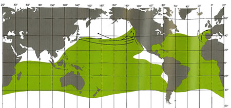
While you might look at a sea surface temperature chart and see the warm water off our coast due to runout from the Columbia and other river systems, the albacore don’t show up until that warm water connects to the warm water south of here. Once that happens, we have what’s known as the tuna highway and it’s just a matter of time before the albacore show.

In the above example you can see the push of the warm water off the NW coast but it still hasn’t connected to the warmer water off the entral California coast. In the example below, you can see a solid line of warm water all the way up. Once you see this, it’s time to start looking for a specific spot to target in you area.
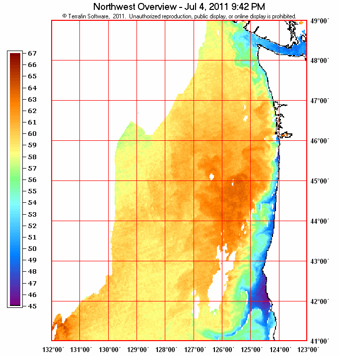
Albacore prefer temperatures ranging from 58 to 64 degrees. With this in mind, many people look for temp breaks, areas where the temp suddenly jumps, before deploying their gear and starting their troll. The chart below shows the SST’s off the coast of Washington in a little more detail, keeping in mind that adult albacore also prefer depths of at least 1,250 feet, look for good edges and temperature breaks of a degree or more as places to start your search.

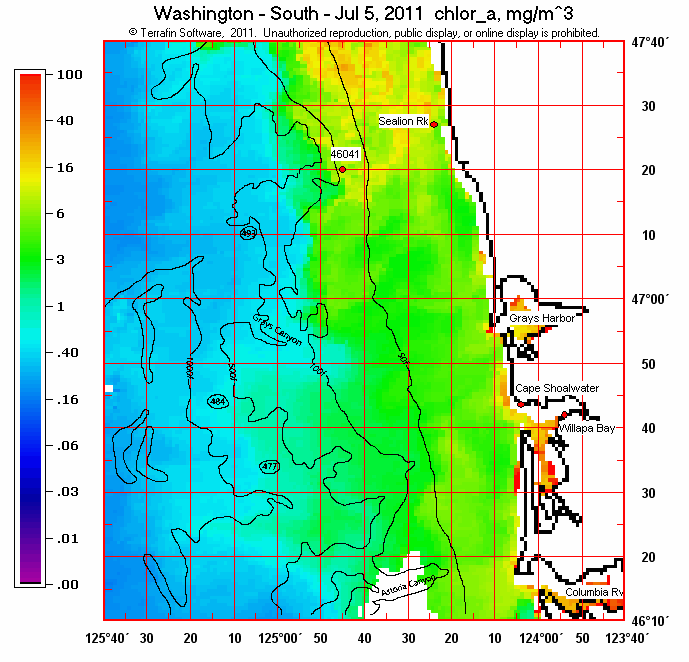
Once you an area with good temps targeted, the next thing you need to do is look at a chlorophyll chart. Chlorophyll is a good indication of the amount of plankton, which is essentially the amount of food in the water in a given area. If you can find a spot that has good concentrations of chlorophyll to match your temps then you have found an area where bait and fish should be concentrated. You can often see a distinct line of blue and green water, if you do, target this area by trolling in and out and along the edges.
Websites like NOAA, Terrafin, and Ripcharts provide these SSTand Chlorophyll charts and a special thanks to Terrafin for allowing the use of these charts in this blog. Now go out and catch some TUNA!
Great info and "how-to" on reading the SST charts! There's so much info available to todays offshore angler that its hard to grasp what is important and how to interpret it. Nice work... Man... it hurt to say that...